Notifications
Clear all
Topic starter
This puppy sure is trying to form. Here's the latest satellite imagery:
Game over, man! Game over! Heh heh, OK, maybe not...:D
http://www.youtube.com/watch?v=dsx2vdn7gpY
Posted : June 13, 2010 2:28 pm
Sheesh! Not already! 🙁
Posted : June 13, 2010 3:52 pm
Topic starter
From wunderground.... It's a bear to read with IE. Go in with another browser if you have one.
"The unthinkable appears to be happening."
http://www.wunderground.com/blog/Levi32/comment.html?entrynum=289
Posted : June 13, 2010 6:46 pm
My oh my. Sure am glad I got the spot on the hurricane chain in Hurricane Hole! Didn't expect to use it so early but glad I expended the energy and time! We have charter guests on board until Sunday so hopefully this thing will stay well south of us but if not I will need a place to put them off for the little storm. Anyone have a vacancy for two guests? They fly out on Sunday at about 1 PM but would be off the boat 24 hours before the storm if it is going to hit us. I am thinking Thursday for off boarding them if it comes our way. Ideas?
Pamela
Posted : June 13, 2010 7:22 pm
Topic starter
As of the 8PM advisory, the NWS now states,
"THERE IS A HIGH CHANCE...60 PERCENT...OF THIS SYSTEM BECOMING A TROPICAL CYCLONE DURING THE NEXT 48 HOURS.
It's quite an impressive storm for this early in June. Sea surface temperatures under this storm are as warm as they were last year during the peak of the hurricane season in August and September. This afternoon there reports of what appears to be a closed center of circulation and an anti-cyclone had formed over the top of it and is tracking with it. There's shear in it's path but, at the very least, we'll probably be in for a bit of a bumpy ride this coming weekend. The projected storm tracks bring it in our general direction.
This one will go into the record books.
Posted : June 14, 2010 12:58 am
Topic starter
RIP 92L. Strong wind shear should tear her apart later today or tomorrow. There's a lot of chatter online saying that she should have been given tropical depression status on Sunday. That would have put her in the history books.
If the Cape Verde wave train forming in June is an indicator, BUCKLE UP!
Posted : June 15, 2010 12:49 pm
Topic starter
She's one scrappy little girl. NWS had her at 0% chance of development yesterday and this morning. The 8PM advisory has her back up to a 20% chance. Fascinating. Whatever is left of her is headed this way.
Posted : June 18, 2010 2:06 am
Topic starter
NWS has issued a flash flood watch for us valid from this afternoon through Sunday afternoon.
"...AS WIDESPREAD RAINFALL TOTALS OF 4 TO 6 INCHES... ARE LIKELY WITH THIS EVENT."
Posted : June 18, 2010 12:59 pm
Aussie, you are going to wear yourself out by the time hurricane season is over.
Posted : June 18, 2010 3:34 pm
Topic starter
😀
I'm a storm junkie. Always have been. The dynamics of these storms fascinate me - Mother Nature putting on a display of immense power. The human tragedy in their wake is heart-wrenching, but the storms themselves - AWESOME!
Posted : June 18, 2010 3:51 pm
Aussie, I will play with you! I am also fascinated by storms. I was more or less blindsided by hurricane Marilyn in 1995 and swore it would never happen again! And of course I make a living playing with yachts so I have a legitimate reason. 🙂
Pamela
Posted : June 18, 2010 4:42 pm
Topic starter
A playmate!! Too cool! Marilyn must have been terrifying. I saw lots of ruins when I lived on STT - twisted steel and concrete walls just torn apart.
We'll keep an eye on 'em and keep your yachts safe!
Posted : June 18, 2010 4:59 pm
Aussie - I find the fascination with storms interesting but somewhat alarming -- where were you during Hugo and Marilyn ? - in STX or STT ?? with a matress pulled over your head huddled with your wife and child in the bathtub for 8 hours after the roof blew off - and waking up to the scenario where everything you ever owned is strewn over 2 miles of hillside and you have no place to live and nothing but the clothes on your back -- Yeah storms are awesome.
Posted : June 19, 2010 5:28 am
Exit, I understand your comment, but I think you are being too hard on Aussie. A hurricane IS an facinating force of nature. Watching it travel towards you, wondering where it will actually go -- great spectator sport. I certainly would agree that one's perception changes after becoming a part of the action. I come from tornado country. You'd be surprised by how many people, when the tornado is on the way, will go outside to watch it. It makes no sense, but it happens every year.
But don't worry, the $$$ we tied up in buying a generator probably means the islands, or at least STX, will now be permanently hurricane free!
Posted : June 19, 2010 9:47 am
😀
I'm a storm junkie. Always have been. The dynamics of these storms fascinate me - Mother Nature putting on a display of immense power. The human tragedy in their wake is heart-wrenching, but the storms themselves - AWESOME!
Aussie,
I'm also fascinated with weather and storms, etc. I appreciate reading your updates here. Thank you.
(tu):-) Jill
Posted : June 19, 2010 11:09 am
A weather website I find interesting, has reports from "local correspondents" from around the Caribbean islands ...
~Jill~
Posted : June 19, 2010 12:46 pm
Topic starter
Thanks Pamela, Linda J, and Jill!
Exit Zero, man I feel your pain and your fear. Riding out a storm as powerful as Marilyn was must have been a terrifying experience. My heart goes out to you. Please understand that I do not mean to minimize, downplay, or make light of the human suffering that follows in the wake of these storms. It is not lost on me and I find nothing "awesome" about about that aspect of them.
No, I wasn't here for Hugo or Marilyn thankfully.
Perhaps I should have said that I'm a science/nature/storm junkie. Everything about the natural world fascinates me and gives me a sense of wonder and awe. It feeds me. And, yes, that includes storms and all of the incredible and immensely powerful forces of nature. Nature can be fragile, gentle and beautiful and it can also be incredibly powerful and destructive. This is an amazing blue ball we live on.
The models on 92L are locking onto a solution this morning that takes 92L into the Gulf of Mexico and forms tropical storm Alex later in the week. This is one tenacious little girl. She failed to develope in extremely favorable conditions and then withstood 30 to 50kt wind shear that should have ripped her apart. What's holding her together? Fascinating. If she forms and heads into that oil spill, what a mess!
One of my favorite resources for storm junkies is www.wunderground.com Go to the member blogs. I picture about half of the folks that post there as sitting in their basements wearing little propeller beanies...LOL...but there are some very knowledgeable contributors on that site.
Posted : June 19, 2010 2:32 pm
I also like www.stormpulse.com
Posted : June 19, 2010 8:45 pm
aussie,
Check out easternuswx.com forums.....wunderground is filled with a bunch of college met students with dreams of chasing tornadoes.
Posted : June 21, 2010 2:31 am
Topic starter
That looks like a great site. Thanks AllMashUp!
There's a lot of chatter online today. The European and Canadian models are indicating that a tropical cyclone will form in the western Caribbean later this week. The European model forecasts a major hurricane making landfall on the northern Gulf coast.
Nothing has formed yet and I sure hope the models are wrong. A major hurricane moving through that oil spill is a nightmare scenario.
Posted : June 21, 2010 1:36 pm
I hate to say, a GULF hurricane is almost inevitable(though maybe Obama can fudge his employment #`s for the clean up(@ our expense)!
Posted : June 22, 2010 1:27 am
DUN,
Do you pay Federal Income Tax?:S
Posted : June 22, 2010 1:30 pm
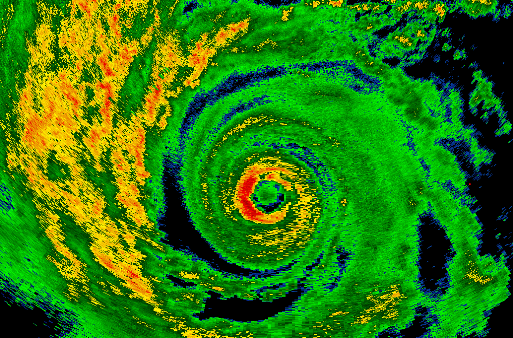
Topic starter
Hurricane Alex is nearing landfall as a cat 2 storm with sustained winds near 100MPH. What a fascinating storm to watch!! Alex is the first June hurricane in 15 years. He was really bombing out as he approached landfall with a minimum central pressure of 948mb. That's what you'd typically see in a cat 4 hurricane. He simply ran out of time before the winds could catch up to the changes in the core.
A sign of what's to come?

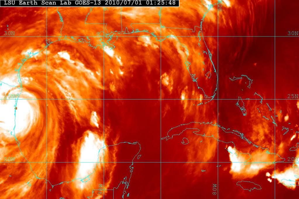
Posted : July 1, 2010 2:02 am